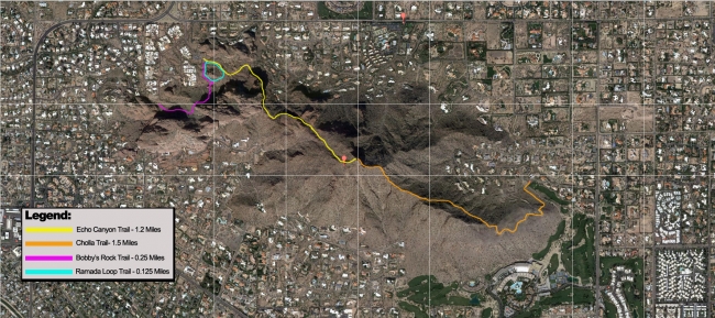
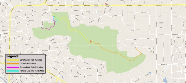
Pictured below are trail maps for all 4 trails on Camelback Mountain.
Please note the trail outlines are general guides and are not exact reflections of each bend or turn in the trail. Be sure to note trail signs and do not venture off main paths.
For more maps and photos of the trail be sure to use our navigation to the far right of this page.
Below the maps are more detailed descriptions of each trail.
Echo Canyon (Summit Trail) – 1.2 miles ~ 1.45 Miles
Summary: Echo Canyon Trail or Summit Trail also commonly referred to as simply “Echo” is one of the most intense and hardcore hiking experiences in Phoenix, Arizona. This is a trail for hiking enthusiasts, out of town visitors and those looking for a difficult workout. Many hike, stop, snap pictures and enjoy the challenge while others hike hard for time. Echo Canyon Trail presents a great all around adventure.
Elevation Gain: 1,264 feet
Challenge: (Extremely difficult) Very good conditioning and/or strong will required to complete this hike. Many people die on Camelback every year due to heat exhaustion, dehydration and falls. This trail has victimized many unprepared and unfortunate hikers.
Terrain (Trail) Description: The Echo Canyon trail starts off with a pacing stair step portion leading up to a steep incline of rock faces. This levels off for a few hundred feet before leading back to steps for another few hundred feet. Then comes the first rail, which is an extremely vertical rock face sandwiched by chain link fence and the mountain edge itself. Running down the east side of this section is a man-made metal rail, installed to help people through this section. Although it can be traversed without rail assistance, many choose to utilize it especially coming down.
After this first rail is a small downward slope and a relatively flat section before entering the second rail section which is not as steep as the first one. Another flat section follows leading up to a choice of two paths. To the left is a sheer rock face, called “The Red Rock Way” and to the right is a highly inclined boulder section. The red rock section rejoins the main trail at many points and also carries all the way to an ancient Native American cave on the north side of the mountain.
Once the two paths rejoin it is a fairly inclined path for the rest of the hike. This includes boulder and gravel sections. Towards the top of the trail it loops back north before reaching the summit.
Update: In January 2014 the Echo Canyon trail reopened after the major overhaul project that not only focused on improving parking, entry and facilities; but also lengthened the trail to avoid erosion. The beginning of the trail now has a slight loop back on itself that is graded all the way up to the first big boulder. The original wooden steps were removed and the ground is leveled out for an easy walk.
Other than signage and other minor upkeep / security items, the remainder of the trail has not been altered by human hands.
Cholla Trail – 1.5 miles
Summary: Along with Echo Canyon Trail, Cholla Trail is one of the most popular hikes in Phoenix Arizona. Cholla Trail is a sweeping and enjoyable hike that provides wonderful views of the Phoenician Resort and golf course as well as the entire valley.
Elevation Gain: 1,200 feet
Challenge: (Difficult) While some may argue, Cholla Trail is easier than the Echo Canyon or Summit Trail. It is still difficult and will require good conditioning and/or strong will to finish.
Terrain (Trail) Description: Cholla Trail starts off fairly flat with many switchbacks and bends in the trail. Many hikers choose to jog or run this portion either up, down or both because it is fairly easy to do so without risk of injury. As Cholla Trail continues it provides great views of the Phoenician Resort while continue to bend and curve and gradually get steeper.
The middle portion of the trail diverges to the north side of the mountain and continues to increase the incline of the hike. After this, there is a small flat section with a make shift helipad for air evacts and then the trail take a more jagged and sharp turn upwards. Many hikers complain that this part of the trail is their least favorite due to the need to “climb” certain portions. This however gives the hike great versatility and provides a challenge finish before reaching the summit.
Bobby’s Rock Trail – 0.25 miles
Summary: A short jaunt off of the main Echo Trail, Bobby’s Rock Trail provides a great wrap up or warm up to the main Echo Canyon trail. It also provides more casual hikers or out of town visitors the ability to enjoy the scenery without facing the challenge of Echo or Cholla.
Elevation Gain: 200 feet
Challenge: Easy
Terrain (Trail) Description: Fairly flat and easy to traverse
Ramada Loop Trail – 0.125 miles
Summary: This short loop allows hikers to experience a shorter hike and provides good training opportunities for the stair portion of Echo Canyon.
Elevation Gain: 100 feet
Challenge: Easy
Terrain (Trail) Description: Includes the stair step beginning of Echo and a portion of Bobby’s Rock Trail.


Be the first to comment